

Occasionally we’re going to have a rummage around previous CabbieBlog posts and attempt to grab a group to view them from a different angle.
In the 1930s London really was put on the map for between 1933 and 1936 four novel cartographic representations reached the public’s attention.

In 1933 Harry Beck’s tube map famously ditched the need for geographical accuracy. He alone realised that all passengers needed to know was how best to get between stations, not their precise locations, or how you arrived there. Apart from being groundbreaking, and later much copied, the map was much more elegant than its predecessors, with all lines running either horizontally, vertically, or at 45 degrees to the layout.

On 3rd October 1934, the day which London Transport renumbered many routes from the former Metropolitan Police ‘Bassom System’ of numbering, into its own sequence, following the acquisition of most of the London independent operators, a map showing all of London’s central bus, tram, trolleybus routes which had started in south-west London a few years earlier and Green Line coach services, which were lettered, was published. Unlike Beck’s map, this needed the geographical locations and therefore was much larger.
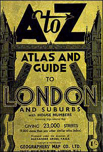
In 1936 the first A-Z became available. It was the inspiration of Phyllis Pearsall, who reputedly walked every street in London to compile her maps, a feat I find hard to believe. Apparently, in the early days, she had to personally fulfil orders by running around town with a wheelbarrow – kind of putting the cart back into cartography.
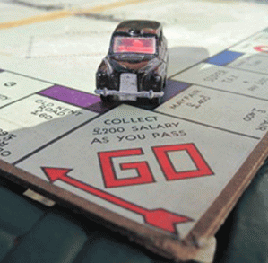
When Waddington’s bought the rights to Monopoly in 1935 the positions on the English version of the iconic board had to be assigned. London was the choice of location and so somebody was tasked to seek out the appropriate ‘Properties’. The onerous job of travelling by cab – surely the reason the Old Kent Road was the only property Sarf of the River – to seek out the board’s positions fell to Waddington’s managing director, Victor Hugo Watson and his secretary Marjorie Phillips. It would be a stretch to call the game a ‘map’, but its idiosyncratic arrangement of streets and stations is certainly one of the most famous representations of London.
Just why was it felt necessary to produce, in the space of four years, these visual aids in London? One factor could be a population explosion during this decade from 6.5 million at the turn of the century to 8.5 million by the mid-30s. With so many people in the capital, and with the building of Metroland ever more were commuting to and from work, there was a pressing need for better cartography.
I can’t think of any other representations of London that have endured, the Tube map can just still be recognised with its modern additions, the A-Z is the go-to reference for aspiring cabbies, and we still have an integrated bus network requiring a visual aid to get around. As for Monopoly, since the game was created in 1936, more than one billion people have played it; making it the most played, and argued about, board game in the world…and did they have to include on the board among the roads and utilities where they stopped off for tea at The Angel Corner House Tea Rooms?
Here are the previous posts links:
Harry Beck’s tube map
Phyllis Pearsall’s A-Z
Monopoly

I used to collect old copies of A-Z map books of London. They are probably in a box in the loft somewhere.
Best wishes, Pete.
LikeLike
Ebay awaits your sale of A-Z copies!
LikeLiked by 1 person