
Category Archives: An urban view

Green Shelters – The Kensingtons
Kensington Park Road
The Kensington Park Road shelter which started life here in 1877 is an anomaly. Today this is upwardly mobile Notting Hill Gate frequented by film-makers.
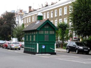
Three decades before the arrival of the shelter, an 1849 report described most houses as ‘merely hovels in a ruinous condition’ and ‘filthy in the extreme’. A medical officer reported that it was ‘one of the most deplorable spots, not only in Kensington but in the whole metropolis’. Life expectancy was just 11 years 7 months compared with the London average of 37.
Just after the last war, the area was still one of the most deprived in the capital as related by Alan Johnson in his memoir This Boy.
Another curiosity is the road’s name – Kensington Park Road – as far as I’m aware, the nearest Kensington Park is in Romford, so this thoroughfare doesn’t take you there or provide a means of leaving the park.
Notting Hill is the sort of place where an orange Fiat 500 is in a shop window displaying pizzas, or sewing machines are stacked floor to ceiling in a frock shop window.
I’m feeling comfortable in some parts around here, but travel north and it’s a different matter.
One of my first bilkers ran away without paying in Portland Road, which has a barrier half-way up the road, acting as a demarcation boundary marking the start of a no-go area.
Kensington Road
This shelter is located on a road that actually takes you to where it promises.
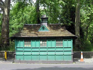
Conveniently situated by some conveniences, it is almost opposite the Albert Hall near to the site of the Great Exhibition of 1850, cabbies call it the ‘All Nations’ referring to the diversity of visitors attending the famous Victorian spectacle.
Striding off towards Scotch Corner I pass the now restored Albert Memorial. Next on my right is, or what was once the Iranian Embassy. On 5 May 1980, Britain realised it had an elite force when the SAS successfully stormed the terrorist-held embassy in Princes Gate after one of the hostages was killed and his body thrown out of the embassy. The soldiers later faced accusations of unnecessarily killing two of the five terrorists, but an inquest into the deaths eventually cleared the SAS of any blame. When I first started driving a cab around London, this building was still a burnt-out shell.
Further down the hill the road now changes its name – to Knightsbridge, thereby giving the lie that Harrods is in Knightsbridge, it’s actually in the more prosaically named Brompton Road, which does go to Brompton.

Just where was London’s first door number?
Many of us know of Number 1, London – Apsley House, built in 1778 on the north side of Piccadilly. At the time, it was next to the main turnpike or toll into central London, so became known as ‘Number 1, London’, because it was the first house you came to once you entered London.
The property’s official address today is 149 Piccadilly, Hyde Park Corner, London, W1J 7NT, but rumours still abound today that if you posted a letter to ‘Number 1, London’ it would reach this address. We haven’t tried this one, but if you do, let me know how you get on.
 Apsley House by Paul Farmer (CC BY-SA 2.0)
Just before a lease for the land was negotiated from the Crown Estate and builders stood around shaking their heads while telling his Lordship they had discovered problems in the build, The Postage Act of 1765 was given Royal Assent, apparently to start numbering houses for the postie.
The full text of the 1765 Postage Act does not contain any direct reference to house numbering, either introducing or for standardising. The Act enabled plans to measure distances along roads, encouraging house numbering, but the Act didn’t directly require numbering.
So when did the first number appear?
Most likely at the start of the eighteenth century, for this is what The British Postal Museum & Archive says:

The first recorded instance of a street being numbered is Prescot Street in Goodmans Fields in 1708. By the end of the century, the numbering of houses had become well established and seems to have been done on the consecutive rather than the odd and even principle which we have now become familiar.
None of this was regulated and numbering systems varied even in the same street. For example about 1780, Craven Street in the Strand had three sets of numbers. There were irregularities everywhere, and the naming of streets and parts of streets was left to the idiosyncrasy or whim of the owner.
Regulation did not take place until 1855 with the passing of the Metropolitan Management Act. For the first time, the power to control and regulate the naming and numbering of streets and houses were provided for and given to the new Board of Works.

That version can be traced back to the 1708 publication, Hatton’s New View of London, which, using slightly different spelling, recorded that:
In Prescott Street, Goodman’s Fields, instead of signs the houses are distinguished by numbers, as the staircases in the Inns of Court and Chancery.
There are hints that house numbering spread throughout the 18th century, all without that 1765 Postage Act. So his Lordship might not have lived in Number 1, London after all.
Protected: Green Shelters – Embankment Place
Green Shelters – Acacia Road
It’s Saturday, 6th February 1875, and a group of middle-class philanthropists are in a self-congratulatory frame of mind, even though the day has seen two trains colliding at Waterloo Station, only three miles away, and the weather is inclement, a portent of the later months of the year when they will experience one of the heaviest snowfalls for a generation.
There are reasons to feel rather smug, Joseph Bazalgette is putting the finishing touches to London’s sewer network, so at least those assembled will not have to face a soakaway again, and London is the richest and most successful city on the planet.
But the reason the one-hundred or so attendees from the Great and the Good were assembled was a witness the Hon. A. Kinnaird, the Vice President of the Cabmen’s Shelter Fund, taking a well-earned break from his duties as a Member of Parliament, to open the first shelter purchased from funds raised.
The choice of Acacia Road to install the first Cabmen’s Shelter in London (other cities already had their version of a place cabbies could shelter, rest and eat) was well chosen. This area of St. John’s Wood is regarded as England’s first ‘garden development’, the first London suburb with lower-density villa housing and frequent avenues, but fewer communal garden squares, construction standards were high and the new inhabitants were bankers, merchants and gentlemen of independent means. With Regent’s Park to the south and Lord’s Cricket Ground a short walk away, the road runs between Wellington Road to Avenue Road.
It was the culmination of a campaign by The Globe newspaper to get these shelters erected to deter cabbies from frequenting alehouses. On Friday, 2nd January 1874 The Globe asked for donations to build cabmen’s shelters, a prototype of which had operated fro 1872 in Knightsbridge. By Christmas, the fund had reached more than £200 sufficient to construct the first one.
Standing in Acacia Road today, with St. John’s Wood Tube Station behind, I can see why this spot was chosen, the Tube Station would 64 years away from providing a means to get around London, and according to Rightmove today’s average price for a house is £5,723,833, clearly, this was always an affluent area in need of cabs.
Private security guards patrol the area on foot day and night and the Israeli Ambassador’s residence, with a police presence, with yards away. The Royal Horse Artillery might have moved out of their barracks in nearby Ordnance Hill to make way for private developers, but there is still enough security around here to assuage the most nervous resident.

The nearest Cabmen’s Shelter today is now a 5-minute walk away in Wellington Place, close to Lords Cricket Ground, hence its nicknames – ‘The Chapel’ or ‘Nursery End’.
